
Dear friends,
I hope that somebody from our community could draw the following map for me:
Take a (non-copyrighted) map of the world and show how far a line 1000km away from the Russian border would reach? A simple map of Russia with the Russian border clearly indicated and then a second “border” 1000km away from the real border would be perfect.
I would like to have a picture to show what is less than 1000km away from Russia and what is closer than 1000km from Russia. So the result would be to show Russia and her border projected 1000km away in all directions (I hope that this is clear enough).
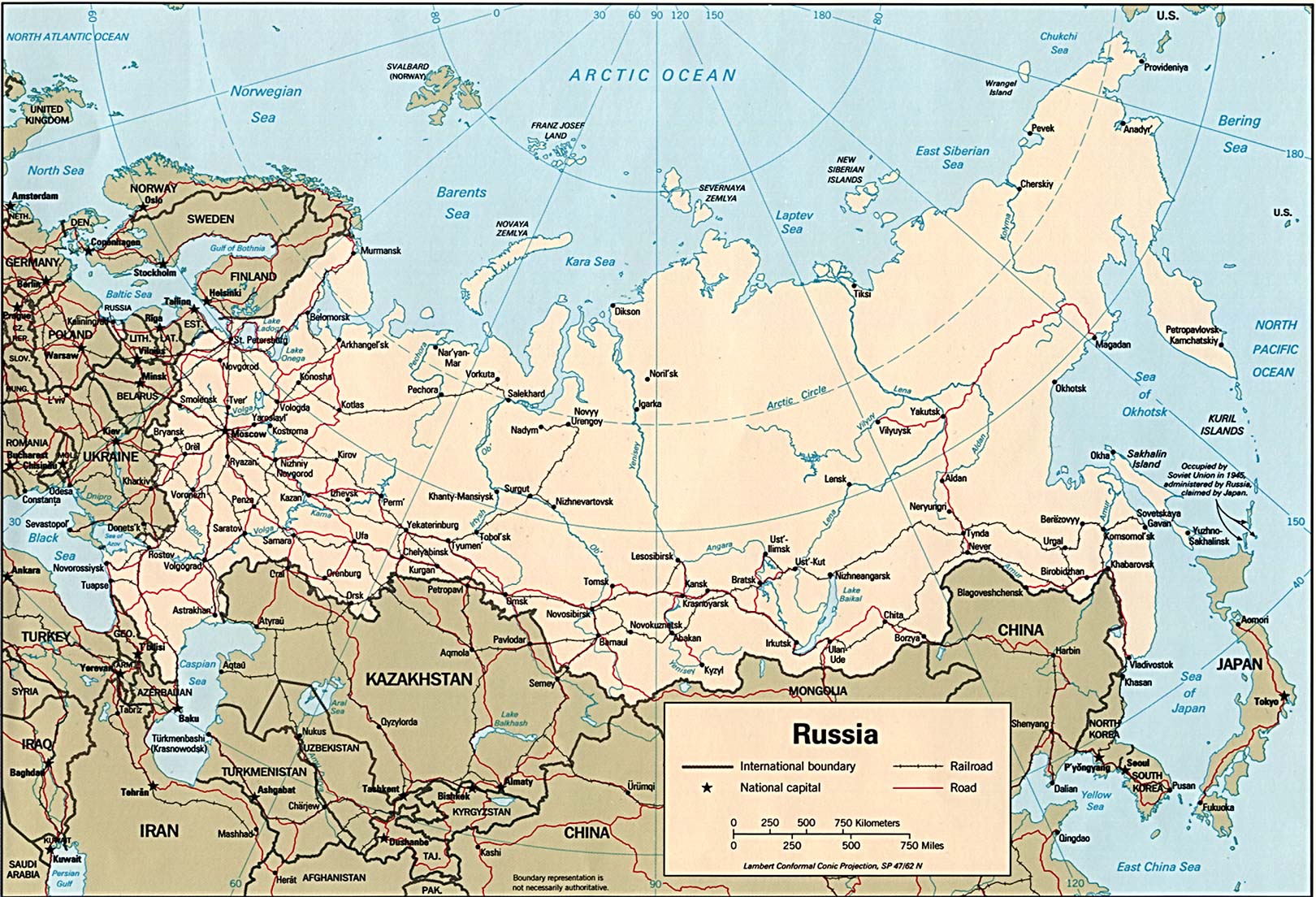
Ideally, the map should be big enough to be able to be zoomed in but there is no need for much detail. A level of detail similar to the one found on this map http://www.lib.utexas.edu/maps/commonwealth/russia.94.jpg should be enough. Another option would be to use this Google map:

Anyway – if you can help with that, please email me at vineyardsaker@gmail.com
Thanks a lot!
The Saker
UPDATE: I wanted to you let you know that I just have been contacted by, I kid you not, a professional Earth Scientist and GIS analyst (!) who very kindly has agreed to help me. I am confident that he will make the map I need. Yet again our *amazing* community has provided exactly the help I needed. Where would I be without all of you!! :-)
While it is not very good looking you can easly place circles with a radius of 1000km on google maps with this site: https://www.freemaptools.com/radius-around-point.htm
That way i once tested just how well Russia is defended by placing the S-400 and the S-500 in strategic points like Kaliningrad, Krim, Armenia etc.
I did this, created like 12 circles, clicking on Russia’s borders, then exported the KML to Google Earth, then used GE’s polygon tool to define a KML polygon outline at the edge of the circles, finished off by unclicking the circle KML, then made a screenshot. emailed it, as proof of concept. Very crude, something like that would be a way
I would not use mercator projection, as it makes Arctic areas look too big.
Hey Rootman, thank you for that. How about a flat earth map?
That’s why perhaps the Buckminster Fuller Dymaxion Map could be used.
https://bfi.org/about-fuller/big-ideas/dymaxion-world/dymaxion-map
“the Fuller Projection Map is the only flat map of the entire surface of the Earth which reveals our planet as one island in one ocean, without any visually obvious distortion of the relative shapes and sizes of the land areas, and without splitting any continents. It was developed by R. Buckminster Fuller who “By 1954, after working on the map for several decades,” finally realized a “satisfactory deck plan of the six and one half sextillion tons Spaceship Earth.” ”
A fun article about the Cahill and Dymaxion maps http://www.wired.com/2013/11/cahill-butterfly-vs-dymaxion-map/
Relax!
It’s those evil monkeys down SW Arabia way who should be recalling their high school years & frantically working their calipers & protractors over a terrain map of S.A.
.
See this here today. Now if this isn’t as blunt a fair warning as you’ll ever see delivered in the press about what they’re set to do next (field testing including special delivery of some new, bigger bang whiz-bangs) if provoked any further in Yemen. Certainly more range than the 50 km or so models they’re using there :
Mon Aug 15, 2016 11:36
Whistleblower Mocks S. Arabia’s Useless Missile Defense, Urges Riyadh to Avoid Warmongering against Iran
TEHRAN (FNA)- Saudi whistleblower Mujtahid, who is believed to be a member of or have a well-connected source in the royal family, warned Riyadh to avoid warmongering against Iran, when its missile defense shields have failed to even defuse the Yemenis’ primary missile attacks.
“The Saudi air defense system has not been able to destroy even the home-made missiles built by the Houthis, let alone intercepting Iran’s ballistic missiles,” Mujtahid wrote on his twitter page on Monday.
“Ansarullah has several times targeted Saudi Arabia’s largest airbase with Qaher missiles in a way that the base is on the verge of closure,” he added.
Sad times. The Hillary is going to get “elected”. She is their chosen one, therefore, the war is inevitable. I don’t think there is anything can be done in this regards. Russia is feverishly getting ready and the western “beast” left no choice to itself – It is cornered by its own greed, stupidity, arrogance and ultimately, lack of consciousness. Hopefully somebody can convince me otherwise.
I meant to say “the evil that took refuge inside Hillary’s corps” but for some reasons when I was posting it this phrase got deleted.
Sad news if so. :(
https://www.youtube.com/watch?v=04kbyrrEnt0
I imported a vector map of Russia into Rhino 3D to draw an Offset Curve around the outside. Some problems. I think that I need a simplified vector map. How detailed do you want it?
I’m not sure about the islands surrounding the land mass…
I’m definitely sure that the arctic regions should be a little larger (earth being round/mercator, etc)
But here’s a quick & dirty Russia + 1000 Kms around it…
https://drive.google.com/open?id=0B6j-8-9kys5AM0JOSlJqQlBTS2c
Looks nice, but forgot Kaliningrad, projecting it from its borders shows some interesting results.
Since it is an exercise, why not project from the Hmeymin Air Base, The Armenian Base, and the Kyrgistan Air base, not Russian territories but certainly targeted already by HATO.
Cannot forget that Russia has new bases on some of those Arctic Islands.
Good job Sir.
I was in drafting for years. Needed is a map with consistent scale for all parts of the map. Otherwise, big headache. With consistent scale map, (almost impossible for large country such as Russia because of earth’s curvature) the simple way I would do it would be with dividers. The thing that looks like a compass, but has two metal points, it is used for transferring, or checking distances accurately on a drawing. so you set the dividers at the correct gap/distance then simply move around the particular diagram, and make construction markings, lightly, at desired offset, and then join all up with curve drawing aid. Like a French curve or something. ( Higher quality diagram: have transparency/tracing paper with the desired out line (map) so that you don’t mess up your high quality map. Get the offset line constructed on the tracing paper that also has the map outline. Get the inset line nice and dark. The use light table, put tracing paper back of map, align everything, and trace onto main map. Use alignment marking when creating tracing.)
Me, again, the draftsman. My actual most desired way to do this would be on an actual globe. Or map lifted off an actual globe, so the distances are accurate.
Also just a thought. What about additional lines to show 1000 km from Moscow and maybe St. Petersburg too.
Don’t forget to include Kaliningrad +1000km.
Well, good to hear some map pro’s have connected with you.
So just a friendly note on map orientation: “We advocate the Upside Down orientation because it is unfamiliar and thus forces us to view the world differently!” (http://www.upside-down-maps.com/about.html )
Btw, something I noticed some years ago which you might find interesting in respect to your passions on possible intersections between this and other (presumed) worlds/dimensions?
At a planetary scale in ‘south up’ mode we can see a slight similarity between the landscape and the Arabic script for “Allah”.
Granted one has to imagine ‘India’ up a bit more but the general pattern is similar. Perhaps the Maldives qualify under certain sea level scenarios? The Americas form the Alif and Africa, India and Australasia form the rest (right to left).
All good art has a signature (for those eyes which wish to ‘see’).
https://images-na.ssl-images-amazon.com/images/I/41mIGfOI5mL.jpg